Tender review
Understand historical seasonal conditions at the proposed project location.
Project weather records
Retrieve location-based weather records for selected dates and use exports, charts and report outputs to support project reviews.
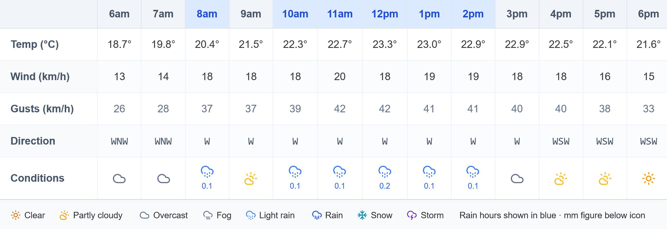
Historical records help project teams test recollection and fragmented site evidence against dated, measurable conditions. Select a project location and period, then review the available daily or hourly observations and derived analysis.
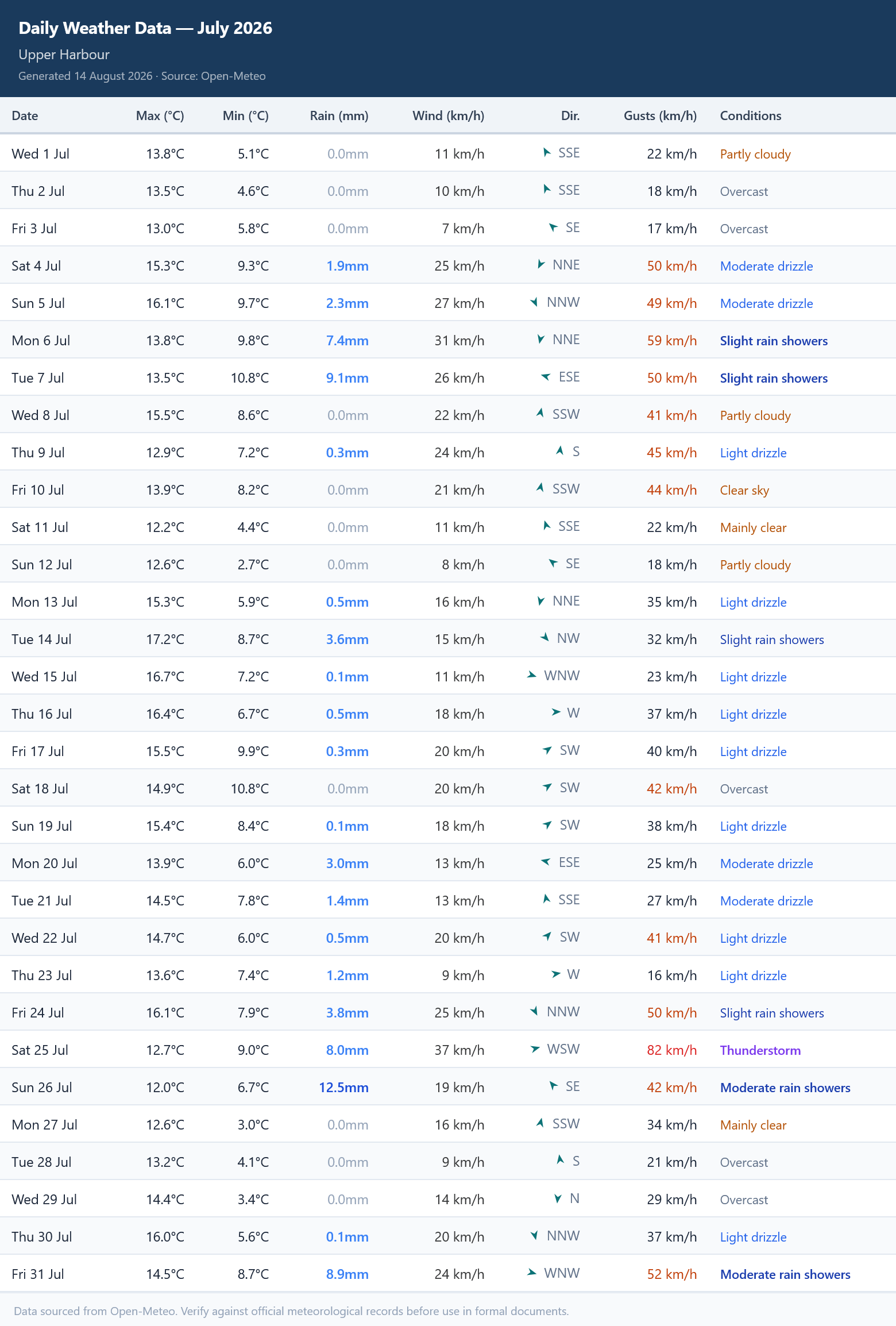
Understand historical seasonal conditions at the proposed project location.
Supplement site diaries, photographs and daily reports with dated weather information.
Identify weather dates for comparison with the programme, affected work and contract thresholds.
When using historical weather in a formal project process, record the selected location, source, period, units, time zone, available observation resolution and any missing information. Confirm whether the contract requires a particular station, source, threshold or statistical method.
Weather records establish conditions, but do not by themselves establish contractual entitlement or critical-path delay. Combine them with notices, contemporaneous site records and programme evidence.
Construction Weather covers the full project weather cycle — from tender through to extension-of-time evidence.
See daily Green, Amber or Red risk gradings for 29 trade operations, with hourly drill-down for flagged days.
Turn forecast risks into editable early-warning notice drafts for project-team review before conditions arrive.
Benchmark a project month against historical data and identify potential qualifying weather events for extension-of-time review.
Use ten years of historical data to estimate average unsuitable days by operation and project month at the proposed location.
See how quantity surveyors use historical records to benchmark project weather, identify qualifying adverse events and build a defensible time-extension claim.
Common Questions
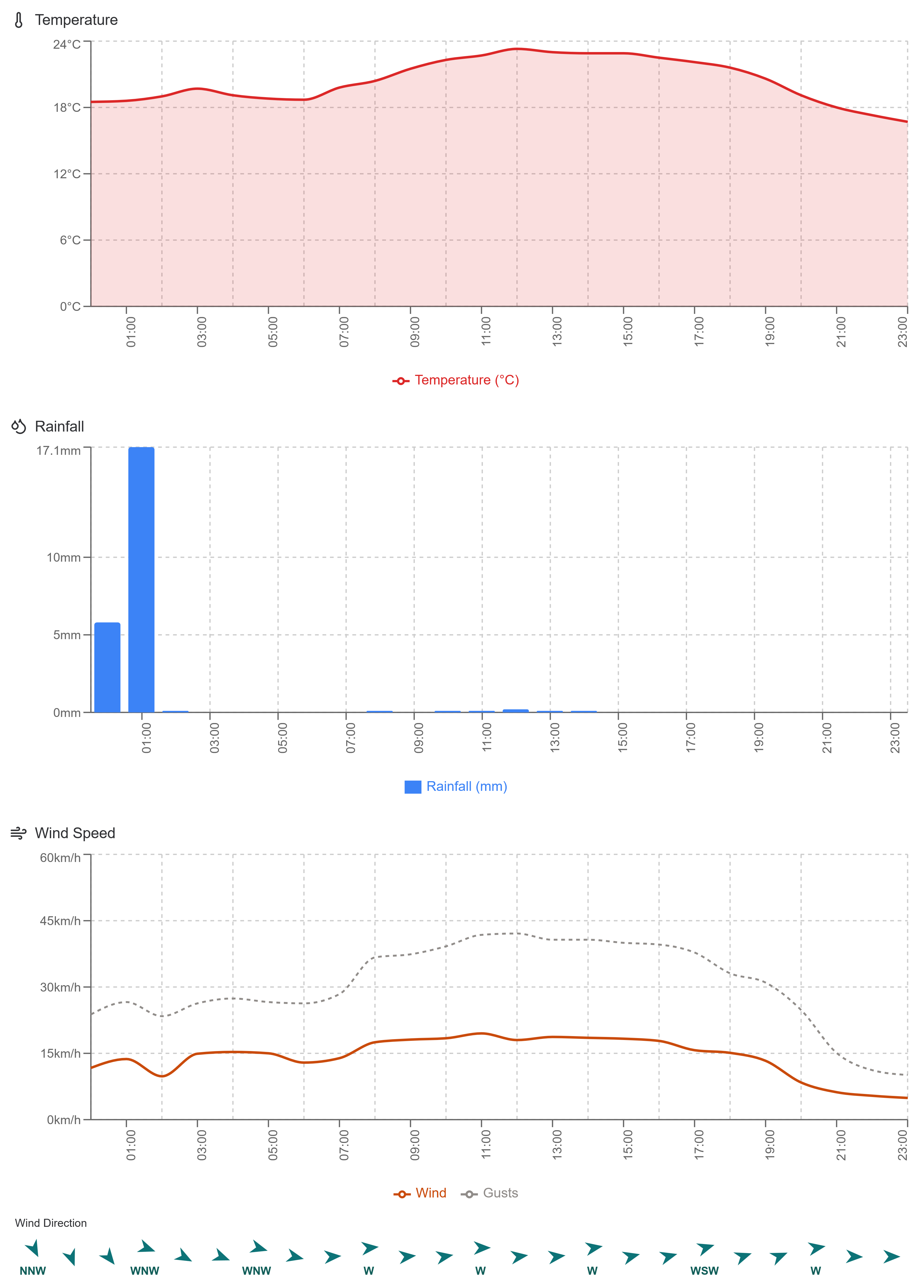
The platform provides daily and hourly historical weather records for any selected project location, including rainfall, wind speed, gust speed, wind direction, temperature (maximum and minimum), and snowfall information. Records are sourced from ERA5 reanalysis data via the Open-Meteo Archive API and are available at daily resolution for any global location, with hourly detail where supported.
ERA5 reanalysis data covers from 1940 to the present day with a short processing lag of a few days. For most construction delay and EOT purposes, data from the last ten years is the most commonly required range and is available on the platform.
Yes. The platform produces Excel exports of daily and hourly weather data, PNG charts for direct inclusion in reports, and formatted report material. These outputs are designed to be copied directly into site records, delay analyses, project review documents and extension-of-time submissions.
Historical weather records establish what conditions occurred on a given date at a project location. They do not by themselves establish contractual entitlement or critical-path delay. A complete delay submission typically requires weather records combined with contemporaneous site records, notices, programme analysis demonstrating critical-path effect, and causation evidence. The platform's outputs support that process as decision-aid information.
Historical weather data is sourced from the ERA5 reanalysis dataset produced by ECMWF, an intergovernmental organisation supported by 35 European states, accessed via the Open-Meteo Archive API. Because the API is publicly accessible, any party can independently reproduce the same figures for the same coordinates, date range and parameters — making the data traceable and verifiable for project records and formal submissions.
Explore construction-focused forecasts, historical records and reporting tools for your next project location.